INTRODUCTION
When this study was first written (Impact on Property Values), and widely referenced, Los Angeles stood at the threshold of transformation. It was a city long defined by freeways—an urban organism shaped around the automobile. To its residents, mobility equated to autonomy, yet that freedom had come at a growing cost. By the late twentieth century, congestion, pollution, and spatial fragmentation were eroding both the city’s function and identity.
The original paper documented this inflection point: a period when Los Angeles recognized that its auto-centric model was unsustainable. Smog alerts routinely blanketed the skyline, commute times lengthened, and freeway expansion began to feel less like progress and more like decline. The reintroduction of rail was thus more than a transportation initiative—it was a symbolic and practical step toward reinvention.
At the core of the original study was the concept of announcement—a technical term denoting the moment when public commitment to transit becomes a quantifiable market signal. This was not mere speculation but an observable stage in policy and finance, where federal matching grants, state legislation, and local tax measures intersected to give investors and property owners measurable confidence. The study’s statistical structure treated this announcement as a temporal marker, dividing pre- and post-investment periods and allowing analysts to isolate how anticipation itself reshaped value.
Thirty years later, that construct has become foundational to urban economic analysis. The “announcement effect” is now a standard variable in transportation economics, used to measure how information, expectation, and policy transparency influence private-sector behavior.
BACKGROUND
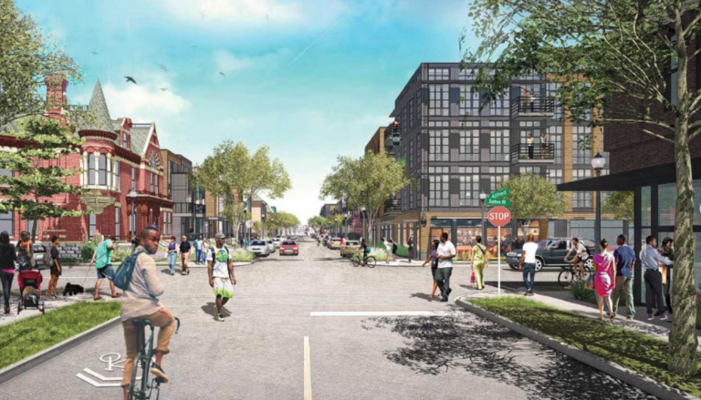
In 1980, Los Angeles voters approved Proposition A—a half-cent sales tax that marked the city’s first large-scale public commitment to rail transit. This decision was decades in the making. Earlier efforts in the 1960s and 1970s had failed amid political fragmentation and fiscal uncertainty, yet mounting environmental pressures and a shifting regional consciousness finally aligned. The 1988 approval of the 22-mile Locally Preferred Alternative (LPA) reflected not only a transportation milestone but also a philosophical shift: a collective belief that mobility, urban form, and equity could be linked through design. In the decades since, the subway system has expanded to more than 100 miles of track, connecting neighborhoods from Downtown Los Angeles to Santa Monica, Long Beach, Pasadena, and the San Fernando Valley. Ridership has grown to nearly 300,000 daily passengers, demonstrating a sustained public demand for transit alternatives in a region once synonymous with car culture. Notably, West Los Angeles and other districts that initially opposed subway construction due to concerns over cost and disruption eventually embraced it, recognizing the long-term benefits in accessibility, commerce, and environmental performance. This evolution underscores how political resistance can transform into civic endorsement once the tangible advantages of connectivity become visible.
From the vantage point of 2025, we can now trace how the seeds planted during that decade grew into a complex, multi-modal system. The once-speculative forecasts of commercial clustering and corridor revitalization materialized gradually over the next three decades. Areas once defined by surface parking and disinvestment—Koreatown, Hollywood, and North Hollywood—emerged as some of the most dynamic mixed-use environments in the region. Yet even as physical transformation unfolded, the predictive power of the study’s statistical model remained its most enduring contribution, demonstrating that real estate markets respond not only to built infrastructure but to the credibility of its promise.
BENEFIT ASSESSMENT AND VALUE CAPTURE IN RETROSPECT
The Benefit Assessment District, introduced in 1983, represented one of Los Angeles’ earliest experiments in value capture financing. Its logic was straightforward yet revolutionary for its time: properties benefiting from public infrastructure should contribute to its cost. The district raised approximately $205 million, leveraging local revenues to attract matching federal and state funds—a mechanism that has since evolved into a cornerstone of modern public-private partnerships.
Looking back, the legal challenges that accompanied its formation proved to be more than procedural hurdles; they shaped the jurisprudence surrounding special assessment financing nationwide.
The geographic context of the study is also crucial to understanding its findings. The analysis centered on Downtown Los Angeles, the city’s economic and civic core, where the concentration of commercial, institutional, and cultural activity positioned properties to gain the greatest benefit from proximity to the Metro Rail. These central districts—rich in office buildings, retail establishments, and emerging mixed-use developments—were already experiencing reinvestment momentum. The introduction of a high-capacity transit system amplified that trajectory, transforming accessibility into measurable value appreciation. As a result, the downtown corridor became the laboratory through which the connection between infrastructure investment and land value was most vividly observed. The eventual Supreme Court affirmation in 1992 validated the principle that targeted assessments tied to measurable benefit are both equitable and constitutional. This legal precedent underpins contemporary funding mechanisms from San Francisco’s Transbay district to Washington D.C.’s Metrorail expansions.
The original study’s treatment of “direct benefits” and “windfalls”—terms describing earned versus unearned property gains—continues to influence how planners and policymakers conceptualize fairness in public investment. Direct benefits stem from improved accessibility, visibility, and commercial activity; windfalls arise when value accrues passively due to public spending. In today’s policy environment, this distinction guides incentive zoning, impact fees, and benefit-sharing frameworks across major urban centers.
METHODOLOGICAL LEGACY
Perhaps the most significant contribution of the 1990 study lies in its methodology. By employing a dual-level control structure—macro (regional demographics) and micro (parcel-specific attributes)—the model achieved a balance rarely seen in early urban economics research. Its statistical design provided replicable tools for cities and academics seeking to quantify the localized effects of major infrastructure investments.
Over the ensuing decades, similar models have been used to analyze transit projects from Atlanta’s BeltLine to Singapore’s MRT expansions. The Los Angeles framework proved notably flexible: its reliance on accessible public data and a transparent control structure allowed subsequent scholars to adapt the approach across diverse geographies and project types. As spatial data technologies evolved, the study’s original framework anticipated many of the analytical capabilities now common in GIS-based spatial analysis and modern hedonic pricing models.
The statistical approach of the study did not emerge in isolation. Rather, it was rooted in a long lineage of economic and geographic theory concerned with the relationship between location, accessibility, and land value. David Ricardo’s theory of differential rent first articulated the principle that land values reflect differences in productivity and locational advantage. Johann Heinrich Thünen later illustrated how transportation costs shape spatial economic patterns through his concentric model of land use surrounding a central market. Alfred Marshall expanded these insights by introducing the concept of agglomeration economies, demonstrating how geographic proximity among firms and workers can generate productivity gains and economic growth. Alfred Weber further refined spatial economic reasoning through industrial location theory, emphasizing the role of transportation and labor costs in determining optimal site selection. August Lösch synthesized these traditions into a broader spatial equilibrium framework, envisioning cities and regions as networks of interacting economic zones shaped by market forces and accessibility.
Mid-twentieth-century urban economists translated these conceptual insights into formal urban land-use models. William Alonso’s bid-rent theory demonstrated how households and firms compete for locations based on accessibility and transportation costs. Richard Muth and Edwin Mills extended this framework through the monocentric city model, linking commuting costs, density patterns, and land values within metropolitan systems. Together, these scholars provided the theoretical architecture that later enabled empirical studies to measure how transportation investments influence urban land markets.
The 1990 Metro Rail study translated this theoretical foundation into a modern empirical context. By treating accessibility as a measurable economic variable, the research operationalized classical location theory within a statistical framework capable of testing real-world infrastructure impacts. Using parcel-level data and regional demographic controls, the study demonstrated how accessibility changes associated with transit investments could be detected through variations in property values. In doing so, it bridged nineteenth-century location theory and twentieth-century urban economics with emerging data-driven analytical methods.
More recently, contemporary scholars have extended and refined these ideas in ways that complement the empirical structure of the study. My 1993 study: Impact on Property Values: A Study of the Los Angeles Metro Rail, applied hedonic pricing methods to examine how rail announcements and anticipated accessibility improvements influence land values. Edward Glaeser’s paper: Growth In Cities, has emphasized the role of human capital and agglomeration in shaping urban economic performance, arguing that dense, well-connected metropolitan environments generate higher productivity and stronger land markets. Michael Storper’s essay: The Regional World: Territorial Development ina Global Economy, has further broadened the analytical framework by examining how institutions, social networks, and regional economic structures interact to shape long-term urban development and innovation dynamics.
In bridging classical and contemporary thought, the Metro Rail study’s methodology connects foundational theories of location with modern empirical urban economics. What Ricardo and Thünen described conceptually—and what Alonso, Muth, and Mills later formalized in urban land-rent theory—the Los Angeles analysis translated into measurable statistical relationships between accessibility and property value. Subsequent scholars, including Fejeran, Glaeser, and Storper, have continued to refine these insights using increasingly sophisticated spatial data and analytical tools. The underlying premise remains constant: improvements in accessibility reshape land markets, reinforcing the enduring relationship between transportation infrastructure and urban economic value.
RESULTS IN HISTORICAL CONTEXT
The strength of the study’s findings can only be understood in light of its methodological rigor. By structuring the research around a pre-test/post-test control model, the analysis established a clear baseline—defining comparable property groups both within and outside the Metro corridor. This dual-level approach, pairing demographic and parcel-level controls, created a filter that isolated the influence of the rail announcement from broader economic trends such as inflation or regional growth. The study’s reliance on standardized sale prices, constant-dollar adjustments, and correlation testing across multiple independent variables produced a framework that could withstand scrutiny and replication. In effect, it translated economic theory into a measurable urban experiment, capturing how policy signals translated into spatial change.
More importantly, the study anticipated the modern concept of the land-use / transportation cycle: improved transit access increases land value; increased land value encourages higher-density development and mixed uses; that development in turn increases ridership and justifies further transit investment. Earlier scholars such as Genevieve Giuliano and Irving N. Taylor explored this interplay of transport infrastructure, urban growth and spatial economics. Their work argued that transport investments do not simply follow development — they shape it and are shaped by it in a feedback loop. In the 21st century, this cycle has become even more salient, as metropolitan regions push for compact, transit-oriented development (TOD) and monitor mode-shift, accessibility metrics and land-value capture. Empirical reviews show that cities with coordinated land-use/transport policy achieve more resilient value outcomes, confirming the relevance of the cycle first set out decades ago.
The study’s findings—showing a 78% appreciation in properties near the corridor compared to 38% elsewhere—offered one of the earliest quantitative validations of transit-induced value increase. Over time, these results have been corroborated by longitudinal data: properties adjacent to Metro stations continue to outperform regional averages, particularly where supportive zoning and density incentives were introduced. What was once predictive has now been proven.
Beyond the numeric accuracy, the study’s real value lies in its foresight. It captured the psychology of urban transformation—the moment when collective belief in a project began to manifest economically. In that sense, the 1990 analysis was not just about property values but about civic faith: how confidence in public works can be monetized, localized, and ultimately realized.
The study’s quantitative precision provides more than historical validation—it offers a replicable model for twenty-first-century transit-oriented development (TOD) analysis. Its framework of paired control groups, inflation-adjusted sale prices, and spatial correlation remains relevant for contemporary urban researchers seeking to measure the relationship between transit investment and neighborhood evolution. Modern applications could incorporate dynamic datasets such as GIS-based land use mapping, ridership analytics, and socio-economic indicators to refine predictive modeling. By adapting the study’s logic, cities today can better forecast how proposed transit projects will influence land values, affordability, and equitable growth outcomes.
In the broader context of TOD planning, the study’s structure also highlights a methodological balance often overlooked: combining quantitative analysis with qualitative insight. While numbers reveal measurable change, understanding the lived experience—the community perception of value and connectivity—completes the cycle. The Los Angeles case remains a template for merging empirical rigor with social interpretation, showing that the most effective urban analyses account for both data and the human behaviors that give it meaning.
CONCLUSION
Three decades later, the Los Angeles Metro Rail stands as both infrastructure and institution. The original study’s framework remains instructive not only for its statistical rigor but also for its interpretive depth—its recognition that cities evolve as much through perception as through construction. Beyond its analytical contributions, the framework has served as a model for shaping integrated land use and transportation policy. Its application demonstrates how empirical evidence can guide planners and decision-makers toward equitable and sustainable development patterns—where growth is concentrated around accessible corridors, reducing emissions, enhancing mobility, and fostering social cohesion. By linking data-driven insight with public policy, the study’s approach illustrates how transportation investments can become instruments of inclusion and resilience, balancing economic opportunity with environmental stewardship. The study’s legacy endures in planning agencies, academic curricula, and financing strategies worldwide.
For the private sector, particularly developers and investors, the study offers a framework for informed decision-making rooted in evidence-based forecasting. Its methodology provides insights into how transportation infrastructure can affect market dynamics, land absorption rates, and development typologies. By applying these principles, developers can more accurately assess the timing and scale of investment, determine the optimal mix of uses, and evaluate the risk profile associated with projects near existing or proposed transit corridors. This approach allows for a more strategic alignment between public goals and private opportunity—where data-driven understanding of accessibility, value capture, and consumer behavior informs both profitability and long-term urban resilience. In essence, the same analytical clarity that guided policymakers three decades ago now equips private actors to make smarter, more sustainable market decisions that reinforce the symbiosis between land use and transportation.
Its message remains clear: when public commitment is credible, markets respond; when infrastructure promises connection, communities align. The story of Los Angeles’ Metro Rail—and of the study that first quantified its economic ripple—reminds us that the true impact of transit investment transcends tracks and tunnels. It reshapes how a city sees itself and what it dares to become.
Equally important, the story of Los Angeles is not unique—it represents a chapter in a broader American narrative of urban rail resurgence. Since the late twentieth century, cities such as Denver, Seattle, Dallas, and Washington, D.C. have followed parallel paths, investing in light rail and commuter systems that have transformed regional growth patterns and redefined urban identity. Denver’s Regional Transportation District (RTD), for instance, built upon the same foundational concepts explored in the Los Angeles study, integrating land use policy with transit expansion to catalyze entire corridors of mixed-use, walkable development. These systems validate the enduring relevance of the original methodology and demonstrate that coordinated land use and transportation policy can yield measurable economic and social benefits.
Looking ahead, the lessons from these metropolitan experiments point toward an even greater ambition: the expansion of high-speed rail across the United States. The analytical frameworks pioneered by early studies like this one can inform the evaluation of future high-speed corridors, ensuring that investments maximize economic benefit while promoting regional equity and sustainability. As global peers—from Japan’s Shinkansen to Europe’s TGV and China’s HSR—continue advancing national networks, the United States stands at a crossroads. To remain competitive, it must approach infrastructure not as a cost but as a generational investment in connectivity, productivity, and shared prosperity. The Los Angeles Metro Rail story reminds us that foresight, when combined with policy courage and analytical rigor, can transform not just a city but the trajectory of a nation.
AUTHOR’S EPILOGUE
When I first set out to study the Los Angeles Metro Rail, the city’s skyline was still defined by the promise of construction cranes and the hum of freeways. The research that followed was both personal and professional—a search for clarity in how cities evolve when belief meets evidence. Three decades later, I am humbled to see how those early models and statistical methods have lived on, guiding planners, investors, and communities toward a more balanced urban future.
This reflection is not merely about one city or one study—it is about the endurance of thoughtful inquiry. Data may quantify outcomes, but it is the persistence of vision, collaboration, and public trust that turns ideas into infrastructure and infrastructure into opportunity. As we look to new frontiers—from transit-oriented development to high-speed rail—the same principle remains: that rigorous analysis, when grounded in equity and imagination, can illuminate the pathways to a more connected, sustainable world.